


Tour de petarel

Spinnaker
User
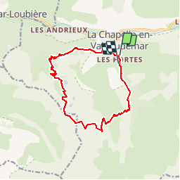

Length
14.4 km

Max alt
2463 m

Uphill gradient
1226 m
Km-Effort
31 km

Min alt
1254 m

Downhill gradient
1242 m
Boucle
No
Creation date :
2019-08-04 04:25:36.673
Updated on :
2019-08-04 19:47:10.251
6h15
Difficulty : Very easy

FREE GPS app for hiking
 SityTrail
IGN / Geographical institutes
SityTrail Plus
The world is yours!
About
Trail Walking of 14.4 km to be discovered at Provence-Alpes-Côte d'Azur, Hautes-Alpes, La Chapelle-en-Valgaudémar. This trail is proposed by Spinnaker.
Positioning
Country:
France
Region :
Provence-Alpes-Côte d'Azur
Department/Province :
Hautes-Alpes
Municipality :
La Chapelle-en-Valgaudémar
Location:
Unknown
Start:(Dec)
Start:(UTM)
278272 ; 4965838 (32T) N.
Comments